Jeff, tell us about your childhood – and when did your interest in the world and travel develop?
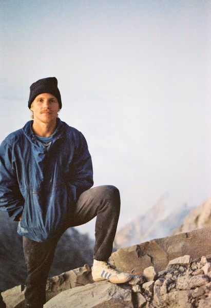
Summit of Mount Merapi, 1983
I was born in San Francisco, California in 1955, the son of Lawrence Shea from Brooklyn (of Irish and Hungarian descent) and Marie (nee Kambic) (of Slovenian descent). I think my interest in travel was in my blood even before I was born. Maybe my Hungarian ancestors were gypsies. My grandfather John Kambic left Slovenia at the age of 12, taking a boat to America.
When I was young, my father would delight me and my two brothers and one sister with “Paulie and Poopsie” stories (that he made up). Paulie and Poopsie would get themselves in all sorts of trouble in adventures all over the world. It is ironic that his stories planted the seeds of my wanderlust since, from the time I was 19, my dear father was vehemently against me traveling. There were other influences, including having a set of encyclopedias at home with photos of strange African masks, my Dad dragging us to museums, National Geographic, my sister Donna’s thick fairytale book with colored illustrations and a very open-minded and far-thinking father that challenged conventional thinking at every turn.
When I was 19, I made a vow to myself that I would travel to every nation on earth. (I achieved that end in 2003, 29 years later. I completed visiting the 2003 TCC list in 2009. It has since changed.)
You are perhaps the most travelled American in terms of being on the road nonstop. What are the good and bad aspects of being a ‘nomad’ for you?
I am never in my comfort zone by personal choice. It would be very comfortable to stay at home and ‘get things done’ and be a normal citizen. But that is not my lot. In my 20s, I had an epiphany in Kathmandu one day of how much there is to know and how little time there is, and this set a fire under me to strive to experience life to its fullest.
The good aspects of “being a nomad” are:
a. Heightening my sense of freedom
b. Continual first-hand education without interference from media
c. Realization of dreams
To the bad:
a. Disappointing people by being away
b. Spending more money than I “should”
c. Time taken away from other dreams that are best served by staying put in one place (such as my ambitions to be a master of karate and a known recording artist)
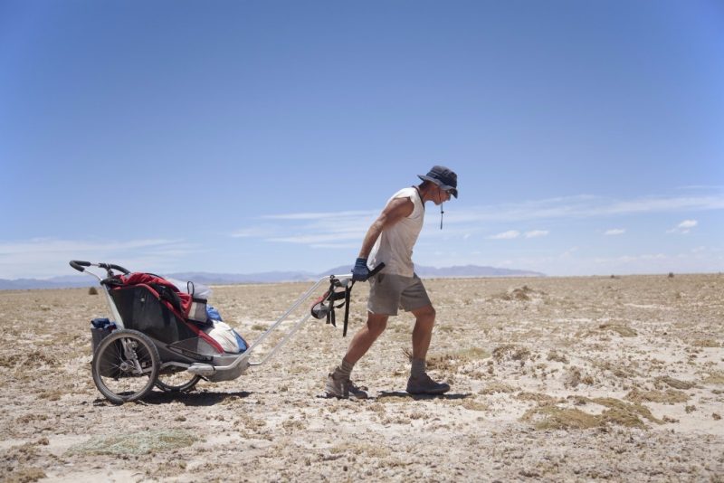
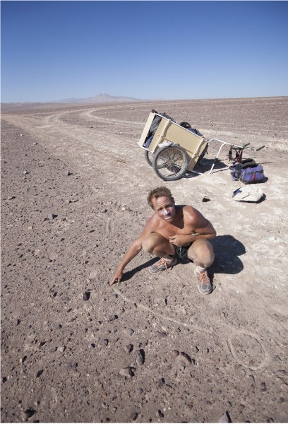
Pulling a cart in Salinas Grande, 2010 – Walk Across the South American Altiplano, the largest highland plateau in the world outside of Tibet – Leg 2 of Jeff’s walk/raft across South America through wilderness areas
You must have very many travel stories. Can you tell us a couple that have really made a difference to you?
First – In 1982, I left on a 26-month journey around the world, beginning by sailing out of San Francisco Bay, USA to Papua New Guinea (PNG). When I got to PNG, I left the boat, went to the end of the “Highlands Highway” (a dirt path), and then I walked out of the Highlands to the Sepik River basin in the north. I hiked for 29 days. When I got to the OK Esai River, a local man built a raft of logs tied together with jungle vine. I floated on that raft for 10 days to the Frieda River, finally arriving at Ambunti on the Sepik River.
The experience in PNG changed my life. For one thing, it made me realize that all the hyperbole about modern man being superior to “primitive man” was nonsense. The forest dwellers were superb naturalists, living in decent harmony with their environment. I came to terms with the perfection of nature. It was during that experience that I conceived of the concept of World Parks. The parks, as I envisioned them, were not parks with rangers, but, rather, large continuous areas, one on each continent, which the world community agreed to leave untouched. People could live there, but internal combustion engines were forbidden. World law would prohibit the areas outside the parks from polluting the World Parks. The concept was a pure one, not tainted by self-interest or economic motivation. It remains my belief that World Parks are necessary for the human race (and would benefit the animals of the world), insofar as that without them, mankind will forfeit the concept of freedom by building infrastructure everywhere, resulting in all areas being under surveillance and under the rule of the commercially-driven rich who are in control of world governments. To this end, in 2012, I founded World Parks Incorporated, a California-based not-for-profit public benefit corporation.
Second – Climbing the Seven Summits – the highest peak on each continent – Denali (North America), Aconcagua (South America), Elbrus (Europe), Everest (Asia), Kilimanjaro (Africa) and Kosciusko (Australia). Of these, the last two are easy, while the others provide varying degrees of difficulty.
(Taking the advice of a friend (the Director of the International Conference of Lawyers for Tibet), I dedicated my Seven Summits adventure to the Dalai Lama’s dream of Tibet as a non-nuclear Zone of Peace. We later received a letter of commendation from the Dalai Lama. I had a flag-maker create a banner to symbolize the project. The Dalai Lama spoke in front of the Seven Summits banner at a Himalayan Foundation dinner in Beverly Hills.
The most difficult of the seven, by far, is Mount Everest. In 1995, I was confronted with the opportunity to join an expedition going up the challenging North Ridge. This route reaches the summit by flanking to the side of the North Face in order to reach the Northeast Ridge. I didn’t use oxygen until I reached the high camp at 8200 meters (26,200 feet). The summit day was the most dangerous day of my life. We climbed rock, snow and ice. At 8800 meters (28,800 feet), we came to the final slope. When I struck my ice axe into the thin snow, I hit hard ice an inch below its surface. I cut steps in the ice in order to make my upward progress more secure. In the region of the summit, I felt like the mountain whispered a secret message to me. Once on top, I considered: how am I going to down-climb what I just up-climbed? On the descent, I was tested to my limits.
This experience made me realize I could do more than I had previously thought I was capable of. Testing my limits became a hallmark of my later adventures, as outlined below.
Third – Walk and raft across South America through wilderness areas (half way completed, still in progress).
In 2005, a rare blood condition I had was diagnosed as possibly fatal, but which was eventually cured. During this period, I took a serious look at my life. Yes, I had fulfilled some dreams, but I had so much more to do. Ten years earlier, my Everest experience had made me question what my limits really were. Facing death piqued my pondering about limitations. I vowed to myself to try to do the extraordinary.
Given my love of adventure, I set my sights on doing an expedition yearly, each one more epic than the last, to test my limits, even though I knew that there was serious risk, especially in solo walks across desolate territories.
Playing into this idea of epic expeditions was the concept of World Parks: to preserve in perpetuity what was remaining of the world’s untouched areas so that our descendants could always enjoy the mystery of the unknown.
These two ideas, Expeditions and World Parks, seemed to go together. I could find candidate areas for World Parks, then explore them on foot. Because such areas were by definition remote, it would fulfill my thirst for adventure. I began to scour maps to search for undeveloped wildernesses as candidate areas for World Parks.
One area with very little infrastructure that I considered was the South American Altiplano. It is the most extensive area of highland plateau on Earth with the exception of Tibet. Its average elevation above sea level is 3,750 meters, or 12,300 feet. It is virtually devoid of fresh groundwater. I had never heard of anyone walking there. I decided to try to cross it on foot by myself in 2010. Inspired by my friend, the great Australian adventurer, Jon Muir, I used a cart to haul water.
After successfully walking across the Altiplano from west to east (across parts of Chile and Argentina), in 2012, I decided to walk from Antofagasta on the Chilean coast across the Atacama Desert, the world’s driest place, meeting up with where my 2010 walk had commenced (in Socaire, Chile).
My walks across the Atacama Desert and the South American Altiplano formed a squiggly, but contiguous, line from Antofagasta on the Chilean Pacific Ocean coast to the termination point of the Andes Mountains in Libertador, Argentina. I considered continuing the journey to the east, beginning where I’d left off in Libertador in 2010. But I couldn’t figure out an elegant and meaningful route. Although my objective was to cross South America through desolate territory, the wetlands east of Libertador seemed an impassable obstacle. After studying my maps, I realized that only 30 kilometers from Libertador, the Rio San Francisco could be accessed. This small river flows into the larger Bermejo River to the east. The Bermejo itself flows about 1000 kilometers southeast to join the Paraná/Paraguay River. By traveling on rivers, I could escape the wetlands, ride by “The Impenetrable Forest” (El Impenetrable) and substantially further my journey eastwards across South America.
In June 2015, I walked from Libertador to the Rio San Francisco in Argentina, then floated down to the Bermejo to kick off this third epic leg of a journey across South America. To date I have traveled 600 kilometers down the Bermejo, establishing 37 camps along this all-sand river. In total, I’ve made 83 camps from the coast of South America to the continent’s midway point on the Bermejo River at Puerto Lavalle, Argentina.
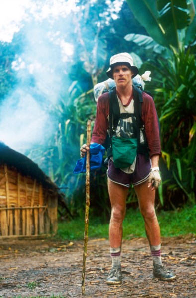
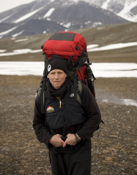
Taking a break on a hike to Lake Kutubu, Papua New Guinea, 1983. This hike was a precursor to walking out of the Highlands of New Guinea.
What are the greatest lessons you have learned from travelling?
- A person can go anywhere on this earth under their own power if they have a will to do so.
- People are basically good. Governments, religions and moralists, all with their own agendas, propagandize to pit people against each other.
- Nature is benign. It should be respected and given free reign. Laws should conform and allow for our original natures to flourish, not be suppressed.
- The most important things are health and freedom. If we have those, we can build anything. Without those, we are poor beyond any measure.
- The more I travel, the more I realize how little I know. This is humbling in a good way.
- Travel is mind-expanding and strengthening to the intellect and spirit.
- Material goods are not as important as experience. (We all too often forget that in our efforts to protect what we have, we give up the joys of spontaneity, freedom, dignity, and other unseen benefits.)
- Always ask questions about what lies ahead, both for the benefit of availing yourself of other’s knowledge and for safety. But don’t listen to negative advice from people who have not actually been there. Go out and get first-hand knowledge.
- Absorb the content of the situation before taking action. Don’t allow circumstances to drive you. Take everything into account and then move in the most sensible direction. Do so with confidence and awareness of time.
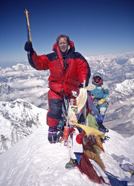
Everest Summit, 1995
In 2003 you made a very elaborate list for the traveller called SISO. Can you explain what exactly this list involves?
SISO stands for Shea-modified International Standards Organization’s 3166-2 list of sub-national territories. In simple terms, SISO is a list of all the provinces of all the countries of the world.
Around 2003, I became aware that the International Standards Organization (ISO) had a country standard, 3166. 3166-2 was a list of sub-national territories, or provinces, 3931 in all. By making a few logical adjustments, I arrived at a list representing the provinces of the world, 3978 in all. SISO is a list of the first-level divisions of every nation in the world, for example, the states of the United States, prefectures of Japan, provinces of France, rayons of Azerbaijan, counties of the UK, divisions of Myanmar, and so on.
Using ISO 3166-2, I created SISO in 2003 in order to establish a permanent and unchanging list of all the territories of the world so that travelers, whether now or a hundred years from now, would have a benchmark upon which to measure their travels and also to compare where they had been in comparison to other travelers, whether in my lifetime or beyond it. Since there were many lists of countries and places, and since they kept changing and expanding every year, I wanted to establish a permanent list that was not arbitrary, but rather that was objective. I also wanted to establish a list with sufficient detail that it adequately addressed the myriad places in the world, many of which are little-known, so that an extreme traveler would have a lifetime of places to visit and study.
The Methodology Used to Create SISO
Using the 2003 version of the International Standards Organization’s 3166-2 list of all the provinces of the world (which they call ‘sub-national territories’), which numbered 3931 in all, I created my list of 3978 provinces. I achieved this by:
a) deleting one each of two overlapping places:
i) Taiwan as a province of China (“CN-71”;”Taiwan) because it was represented on the same list as a country with constituent territories (e.g., “TW-CHA*”;”Changhua” district)
ii) US Minor Outlying Islands as a province of the United States because it was also represented on the same list by its constituent territories (e.g., “UM-79”;”Wake Island”)
b) Adding back 49 territories that were acknowledged on ISO’s national list (3166-1) but not on their sub-national list (3166-2) because these places did not have any provinces within them at the time:
Andorra, Anguilla, Antarctica, Antigua and Barbuda, Aruba, Barbados, Bermuda, Bouvet island, British Indian Ocean Territory, Cayman Islands, Christmas Island, Cocos (Keeling) Islands, Cook Islands, Dominica, Falkland Islands (Malvinas), Faroe Islands, French Guiana, Gibraltar, Greenland, Grenada, Guadeloupe, Heard Island and McDonald Islands, Holy See (Vatican City State), Liechtenstein, Macedonia (The former Yugoslav Republic of), Malta, Martinique, Monaco, Montserrat, Nauru, Netherlands Antilles, Niue, Norfolk Island, Palau, Palestinian Territory (Occupied), Pitcairn, Réunion, Saint Kitts and Nevis, Saint Lucia, Saint Vincent and the Grenadines, San Marino, Seychelles, Singapore, South Georgia and the South Sandwich Islands, Tokelau, Tonga, Turks and Caicos Islands, Tuvalu, Virgin Islands (British).
c) The math therefore is 3931 – 2 + 49 = 3978. This is the number of provinces in SISO’s “Combined ISO 3166 list.”
As of the time of this writing, SISO – although it has been mentioned in the press – is mostly known only to a very small list of extreme travelers who take an interest in such detail. Even with its limited public exposure, it is part of an ongoing controversy amongst extreme travelers as to what constitutes an appropriate measurement of travel for those who have already been to every country in the world. There are many existing country lists beyond SISO and TBT – e.g., DX Ham Radio Operators, Globetrotters, Guinness, ISO 3166-2, Most Traveled People, Travelers Century Club, United Nations registry of countries.
The following factors make the SISO list important:
a) SISO is the only permanent list. The problem that I have with all of the other lists is that they change constantly. Unless there is a permanent list, there is no objective way to compare notes with other travelers today let alone compare notes between a traveler today and one 100 years from now. Even the ISO list changes. SISO will allow for travelers now and in the future to compare where they have been and to organize notes and photos in a uniform way.
b) SISO is a more detailed list than the others.
c) SISO is based on an internationally recognized standard that was compiled by constituent countries. All of the other lists, with the exception of ISO and United Nations, are based on arbitrary standards.
d) SISO takes ISO 3166-2 and makes is user-friendly. In addition to the permanent “Combined ISO 3166-2 list,” SISO also contains an Official Unlisted Places list, which allows for recognition of other “Official” lists (e.g., Travelers Century Club) that are not represented under the “Combined ISO 3166-2 list.”
SISO will allow any traveler in any era a sensible basis to compare where they have been and what they have done with respect to travelers in history, such as Jorge Sanchez or myself.
Chile, drawing the analogous circle and the line illustrating the dynamic life, 2012. Jeff illustrates his idea to Esquire/Playboy writer John H. Richardson, who accompanied him on the first nine days of his walk across the Atacama.
“I was trying to explain to John that the human race could elevate itself by redirecting its energies. For example, do away with the militaries protecting man-made, man-imagined borders protecting man-imagined countries. Their energy could be put to useful things like researching what makes people happy.
I drew a circle in the ground. This, I said, represented how most people expend their energies, in repetitive jobs. Then I drew a line, like a single vector. This, I said, is how people could live, moving from one place in their lives to another, going from one state of being to another. John took a photograph of me with my diagram in the desert sand.”
Today, thebesttravelled.com launches SISO online – what do you expect from it being available on the website?
Since TBT is the most popular extreme travelers’ website, I am hoping that many people will become aware of SISO’s existence and importance.
Realistically, how many people do you think could complete 50% of the SISO list? And what benefits would doing as much as possible of the list give to a traveller?
50% of SISO is 1989 provinces. There may be about 10 people that have reached that many, but I doubt there are a lot more than that. I think this number could reach 40 within a few years if the list becomes popular. SISO really requires deliberate effort and accurate record-keeping.
I think that once travelers start to use SISO, they will discover its merits. For me personally, it has provided a marvelous tool for seeing the world in a new way. I think others will find the idea of going to every province of a country an engaging way to travel. Rather than focus on places that people tell you about, you simply go ‘everywhere’ in a given country and discover it yourself. You will be surprised by what you find.
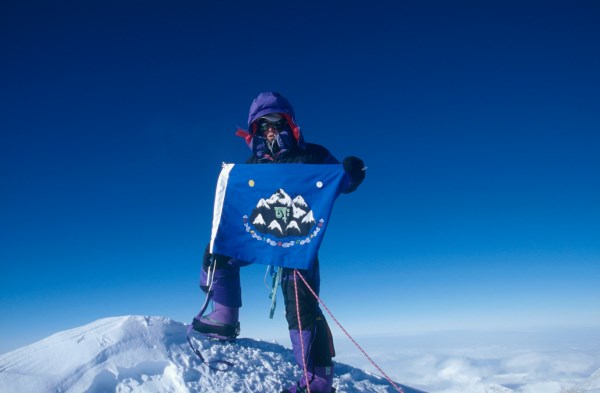
The top of Vinson with the Seven Summit flag, 2007
Jeff Shea completes the Seven Summits with his ascent of Mount Vinson, Antarctica’s highest peak.
You still travel a lot. What are your travel plans for 2017?
I have two major projects for 2017-2018:
a. To complete my walk/raft adventure across South America through wilderness areas.
b. To complete my exploration of the previously unexplored Meseta de Ichúm in Venezuela.
My 2017 looks like this:
January 2017 – Helicopter expedition to rarely visited tepuis in eastern Venezuela
February 2017 – Ski in Bamien Valley in Afghanistan
March 2017 – Walk in Gorno-Badakhshan in Tajikistan with Jorge Sanchez
April 2017 – Complete my descent of the Bermejo River in Argentina
May 2017 – Walking east from my termination point on the Bermejo River to the border of Brazil
June 2017 – Traveling from Vancouver, Canada to Prudhoe Bay, Alaska on Arctic Ocean
July 2017 – Traveling from Vancouver, Canada to Halifax, Nova Scotia
August 2017 – Traveling from Canberra to Perth to Darwin to Brisbane, Australia
September 2017 – Walking from Brazil/Argentina border towards the Atlantic coast
October 2017 – Completing the walk to Atlantic coast (thus completing walking/rafting across South America through wilderness areas)
November 2017 – Home
December 2017 – Home
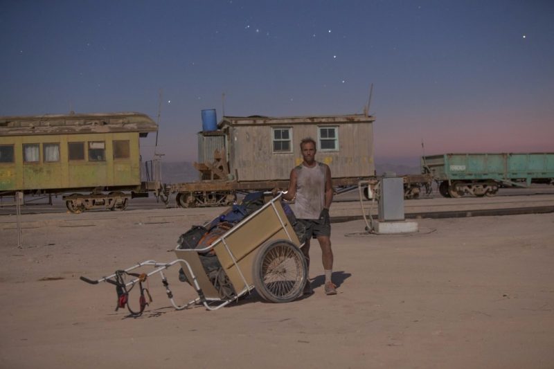
Antofagasta province in Chile at the haunted estación Valencia, 2012 – Walk Across the Atacama Desert – Leg 2 of Jeff’s walk/raft across South America through wilderness areas.
Finally our signature quirky question we ask many travellers – if you could invite four people from any period in human history to dinner, who would they be and why?
Captain Cook – to discuss his amazing experiences in the Pacific
Marco Polo – to discuss the sights along the way during his vast journeys
Jesus Christ – to hear first-hand of His teachings and to ask questions about His philosophies
Cleopatra – to hear her views on life.
Rather see the wonders of the world abroad, than… living dully sluggarized at home, wear out thy youth with shapeless idleness. – Shakespeare
Bliss Bugt, Greenland, 2007
The most northern coast in the world – Jeff joined Dennis Schmitt in Dennis’ Discovery of Stray Dog West Island, one of the world’s three most northern points of land.
All the photos in this interview are from Jeff’ s personal collection.